


Relational Urban Model: Santos
In 2013 Arup DTF funding was granted for the study of the applicability of Relational Urban Models as new working methodologies in emerging economies. The funding is granted for the collaborative research between Arup, Relational Urbanism Ltd and ShenZhen University. The aim of the research was to aid and develop a new approach to Master-planning in emergent Economies based on the use of Relational Urban Models (RUM). The research shall prove that these models help the discussion and the allocation of development area (Gross Floor Area or GFA) in a master planning proposal according simultaneously to architectural concepts, infrastructure constraints and economic criteria. The research project was implemented in two sites: Baishizhou (China) and Santos (Brazil)
A RUM is a digital design interface that generates 3D massing of urban environments derived from parameters (both mathematical and intuitive) as well as the representation of key infrastructure and environmental variables (traffic, CO2 emissions, built area). Its main advantages are:
•It is a dynamic tool that updates in real time a 3d model and the output data (traffic, cost, others) with the manipulation of the input variables.
•It is tailored to be understood by non-expert audience and to be used during negotiation workshops.
•The simultaneous visualization of design parameters and 3d massing allows for the discussion on how urban form is related to infrastructure requirements.
•It is a dynamic model that should enable the solution of complex negotiations running in simultaneously with the interface. This can help city governments and public institutions to develop strategies to incentivize private investment within city wide policy frameworks.
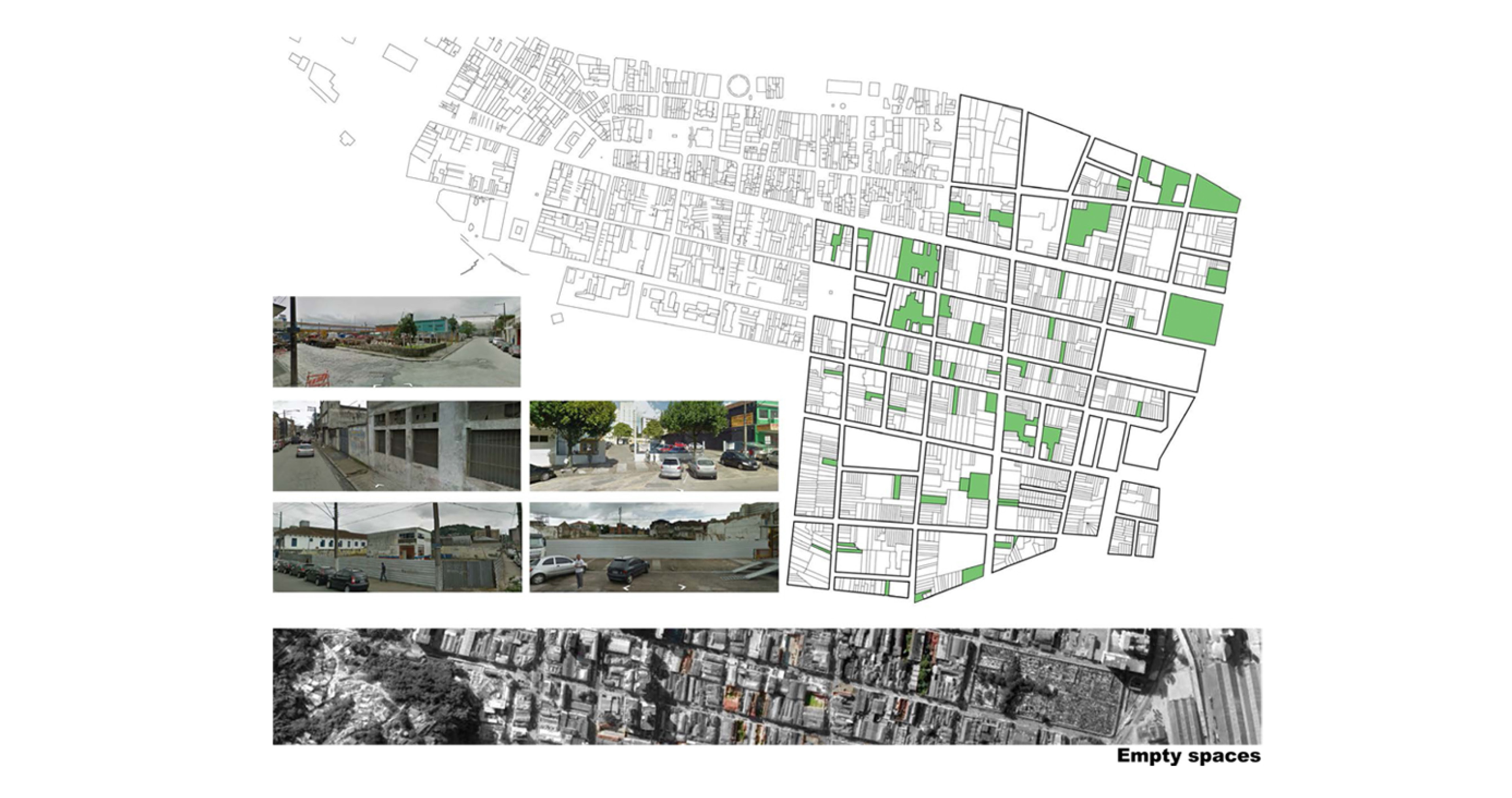
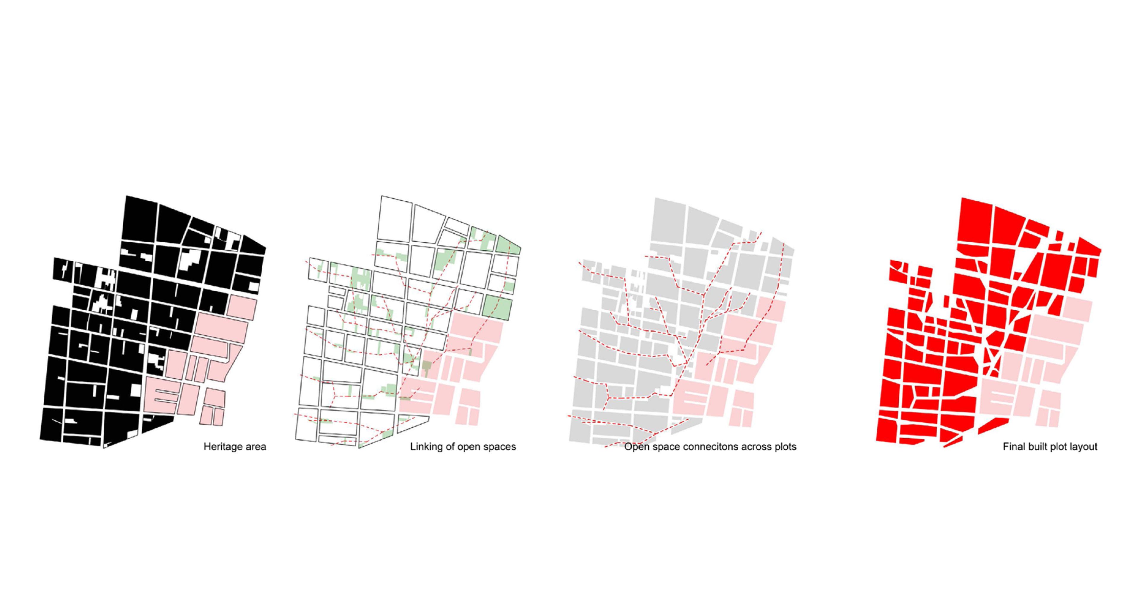
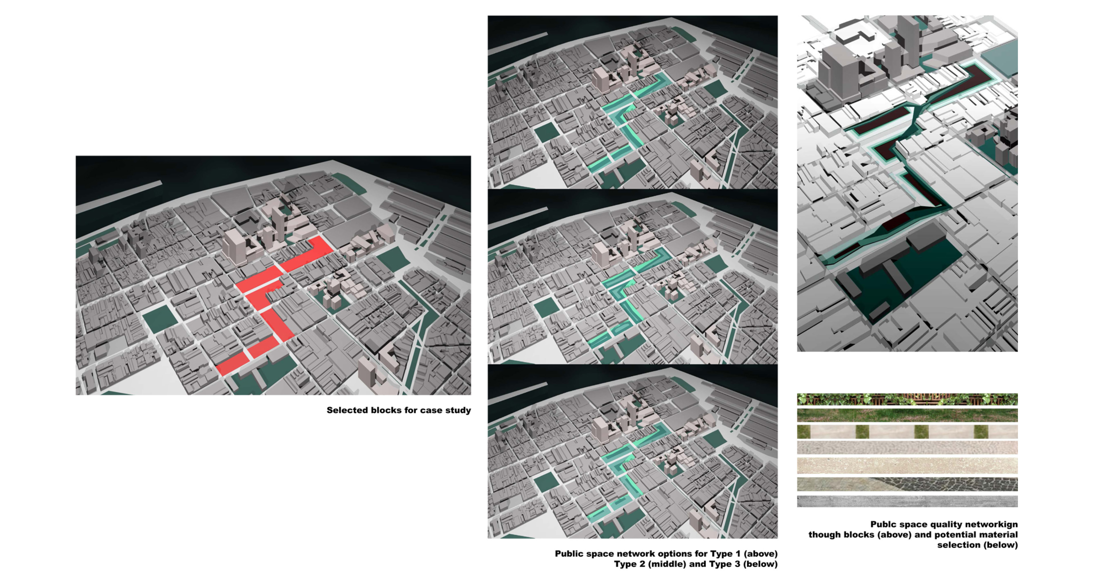
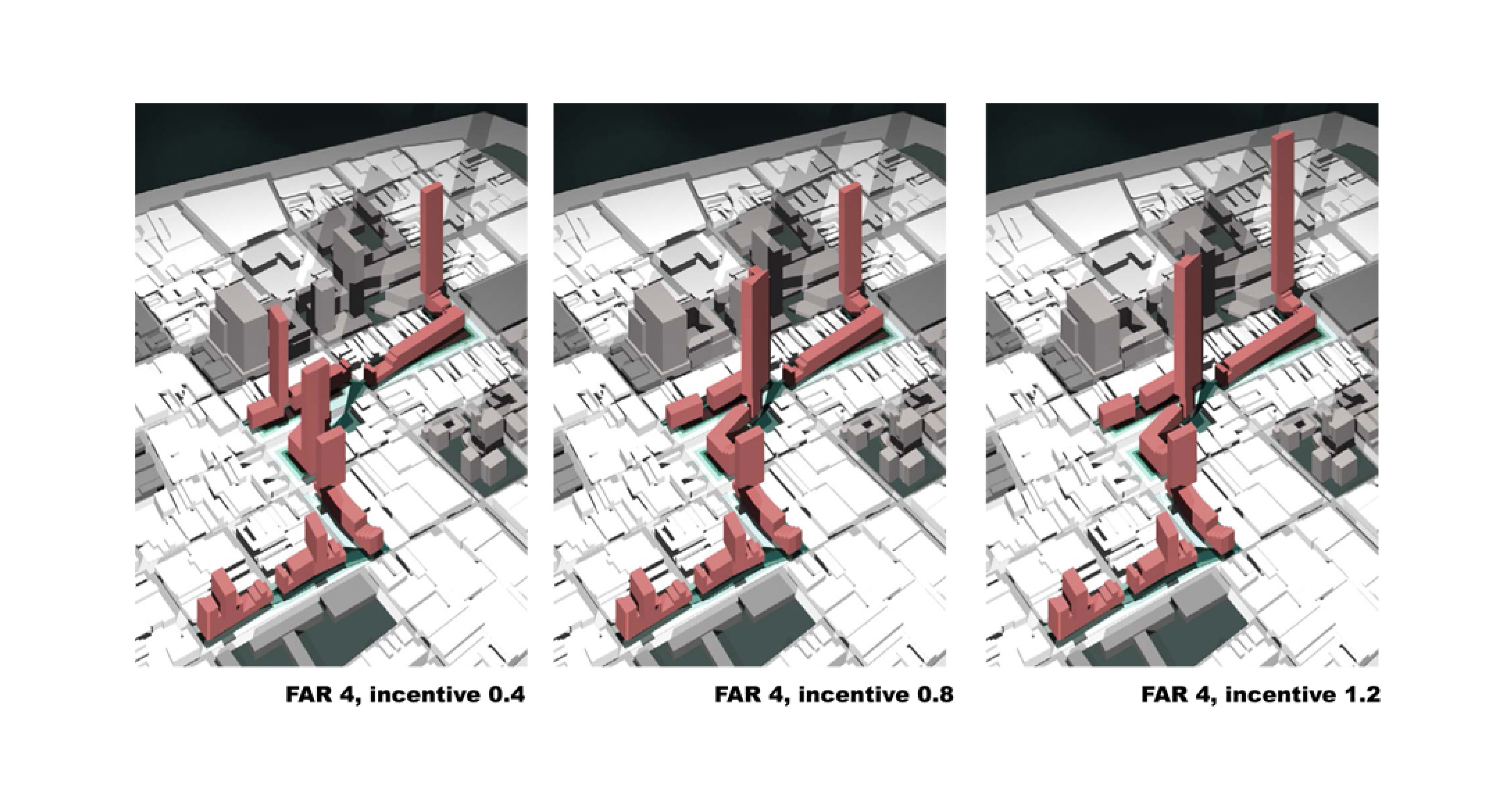
The municipality of Santos aims to develop a masterplan for the areas of Vila Nova and Paquetà, a region of 78Ha. There is the need to devise an overall strategy for the redevelopment of the area that could go beyond the current policy of even attribution of the same rights in terms of FAR and maximum height of buildings to each plot; one of the critical aspects of the project is to propose a re-parcel strategy and introduce public space in the area. In order to achieve the objectives previously described, a strategy for the development of the RUM has been adopted which can be described by the following points:
•The Inclusion of open spaces: In order to increase the value of the common space, the design should allow for generation of open spaces in and around the core of the blocks in such a way that it generates pedestrian networks which complement the regular grid of the city
•An incentivising mechanism for private investors to generate public spaces: This redesign of interior areas of the block could be achieved through the incentivising of provision of public space in or across the building blocks through extra allowances on GFA. (ie investment in public space can be linked to obtaining planning permission for larger quantities of GFA in the same plot).
•Link the 3D results to databases: The model should evaluate and quantify the cost of provision of landscape areas (investment by the developers) in order to estimate extra FAR to be allowed as compensation.
- [FIRST PRIZE]
- [Category] Research Project
- [Institution] Arup, Relational Urbanism and Shenzhen University
- [year] 2013
- [Leaders] Enriqueta Llabres and Eduardo Rico
- [Team] Immanuel Koh, Jung Hyun, Juan Carpio.
Relational Urban Model: Santos
In 2013 Arup DTF funding was granted for the study of the applicability of Relational Urban Models as new working methodologies in emerging economies. The funding is granted for the collaborative research between Arup, Relational Urbanism Ltd and ShenZhen University. The aim of the research was to aid and develop a new approach to Master-planning in emergent Economies based on the use of Relational Urban Models (RUM). The research shall prove that these models help the discussion and the allocation of development area (Gross Floor Area or GFA) in a master planning proposal according simultaneously to architectural concepts, infrastructure constraints and economic criteria. The research project was implemented in two sites: Baishizhou (China) and Santos (Brazil)
A RUM is a digital design interface that generates 3D massing of urban environments derived from parameters (both mathematical and intuitive) as well as the representation of key infrastructure and environmental variables (traffic, CO2 emissions, built area). Its main advantages are:
•It is a dynamic tool that updates in real time a 3d model and the output data (traffic, cost, others) with the manipulation of the input variables.
•It is tailored to be understood by non-expert audience and to be used during negotiation workshops.
•The simultaneous visualization of design parameters and 3d massing allows for the discussion on how urban form is related to infrastructure requirements.
•It is a dynamic model that should enable the solution of complex negotiations running in simultaneously with the interface. This can help city governments and public institutions to develop strategies to incentivize private investment within city wide policy frameworks.
The municipality of Santos aims to develop a masterplan for the areas of Vila Nova and Paquetà, a region of 78Ha. There is the need to devise an overall strategy for the redevelopment of the area that could go beyond the current policy of even attribution of the same rights in terms of FAR and maximum height of buildings to each plot; one of the critical aspects of the project is to propose a re-parcel strategy and introduce public space in the area. In order to achieve the objectives previously described, a strategy for the development of the RUM has been adopted which can be described by the following points:
•The Inclusion of open spaces: In order to increase the value of the common space, the design should allow for generation of open spaces in and around the core of the blocks in such a way that it generates pedestrian networks which complement the regular grid of the city
•An incentivising mechanism for private investors to generate public spaces: This redesign of interior areas of the block could be achieved through the incentivising of provision of public space in or across the building blocks through extra allowances on GFA. (ie investment in public space can be linked to obtaining planning permission for larger quantities of GFA in the same plot).
•Link the 3D results to databases: The model should evaluate and quantify the cost of provision of landscape areas (investment by the developers) in order to estimate extra FAR to be allowed as compensation.